Some maps of the Maamturks Area.

halfcorg.jpg (16274 bytes) 
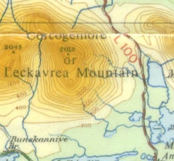
This is a piece of the half inch to a mile map published by the Ordnance Survey of Ireland in 1978. Leckavrea is now regarded as the mountain top right.

This scale is   1:126720 when expressed as a ratio.

The map is difficult to use because of the minute detail and because of the obtrusive layer tinting. The brown contours simply do not stand out in the upper areas over 1500 ft.  The contours are at 100 foot intervals, which is very nearly 30m.

hashcorg..jpg (35351 bytes) This is a section of the one inch to one mile hachured map, also showing Corgemore.  It has lost quite a lot in reproduction, scanning and size reduction.  The originals are a lot more impressive.
gscorg.jpg (29326 bytes) Perhaps the map with the oddest origin in my collection is this one.  It is a British large sheet one inch to a mile map produced during the Second World War. Although a black and white one inch map was available, the sheet size of these was small and fairly impractical.  These maps were produced for use by British forces in the event of an invasion of the country.  They are better than the small sheet maps because they cover a decent sized area and because they make some attempt at colouring.
gsinfo.jpg (4358 bytes)
This is the imprint on the map.  Extraordinary that anyone would have produced three editions between 1940 and 1942.  And then they weren't used.  A number of them were given to the Irish army and from there to hillwalkers in the late 1970's.
mc_corg.jpg (53468 bytes) This is a sample of the 1:50000 map produced by Folding Landcapes.  See acknowledgement.

When it came out in 1986 it was well in advance of anything else available for hillwalking purposes and still is in many ways.
Amongst its advantages are that the contours are readable on the hills (when water is pouring over your mapcase, the wind is making the map flap and it's getting dark i.e. when you really need it).  It attempts to show crags explicitly, something not done by the OS in the Republic (they do in the North).  The area covered is just right for hillwalkers.

Disadvantages in my opinion are that the contour interval at 30m is too great. I would prefer that some of the well established anglicised names such as Letterbreckaun, as used by the OS, would have been included alongside the Irish names.


Acknowledgement.
This is a sample from the new map produced by Harveys of the same area.  The map has a scale of 1:30,000 with a contour interval of 15m. Advantages of this map include
a.  attempt to represent the ground by colouring or shading
b.  no height shading obscuring detail
c.  smaller lettering of some of the major tops
d.  more peaks named, generally bilingually
e.  much better paper
f.  no awkward overlap

Disadvantages include:

a.  difficult to use scales particularly the 15m contour interval and 1:30000 inconsistent with the OS series.
b.  yet another renaming of certain peaks for example Binn idir an da Log, which previously was known as Binn Bhan is now Barrslievenaroy.
c.  I would be suspicious about the accuracy or usefulness of the boulder field markings and crags marked for example on the descent from Binn idir an da Log to Mam Ochoige.  

Overall.  This is the main map I will use in future.


Return to Maamturks: General Information page.