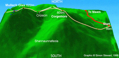
| Start Corgemore Crúiscin Mullach Glas |
Binn Mhór Binn Ramhar Maumeen Patrickswell and the first lake. |
 |
|||||||||
|
|
|||||||||||
| Start Corgemore Crúiscin Mullach Glas |
Binn Mhór Binn Ramhar Maumeen Patrickswell and the first lake. |
|
|||||||||
|
|
|||||||||||
|
Start The walk starts at the highest point on the road between Maam and Maam Cross. (This is in Connemara, a part of County Galway, Ireland. Map.) |
| If you look at the route on the model, you
can see that it veers to the left at the start. In practice I usually go even
further left to reach a buttress from which it is considerably easier to climb, though
longer. Navigation is no harder on this route since the summit is a natural
'collecting feature'. With 22% of the climbing of the whole walk on this one ascent, it
pays to choose a moderate route for pacing reasons. The ground underfoot is the hard quartzite that makes up all but the last fifth of the walk. Little vegetation gathers on the slopes. Nevertheless at the start it can be very wet until you have cleared the bogland. |
|
| You can view the model above as a "3d model" which you can look at from different angles, fly through etc. (Information on VRML and problems) | Virtual Reality View. (in separate window) |
| Robert Lloyd Praeger wrote in TWIW: "A traverse of the whole ridge from Maam
Cross to Leenane provides a glorious day's walking, but the main interest will lie not in
the hills themselves, but in the striking and varied scenery on either hand." If you are lucky enough to do this walk on a day with good visibility at the start, you will see Leckavrea to the east, with the sun appearing over it. Looking northwards is also rewarding: |
|
 |
A View from Corgemore early one morning, with Joyces Country to the right. Photos: 1993 |
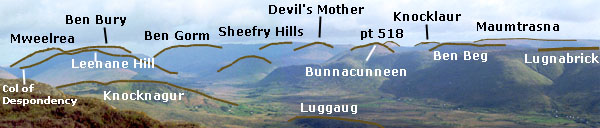 |
Identification of the hills and mountains of the view above. |
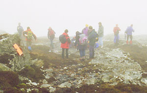
| Corgemore However, more likely than not it will be mist rather than vista. You will probably encounter poor visibility for some or even all of the walk due to the western climate (see reference for more detail). As is written in the section on safety, don't try the Maamturks if you aren't comfortable in mist. Corgemore is also known as Corcóg on MC (The Mountains of Connemara map see sample). |
|
| The name means beehive, which is a fair description of the shape, after erosion, of many of the quartzite peaks in the Turks and Bens. The navigation from this summit can be difficult in mist. From maps and the model above, you will see that you need to head down the ridge and then turn left when you come opposite the spur from Mullach Glas. My routecard shows a Naismith time of 9 mins from Corgemore for this, however, with the very broken nature of the ground, I would think 15 to 18 minutes is more accurate in practice. Tip. In bad weather, drop off the side of the ridge to the left well before the time and find a fence. Walk along the fence until you find the col. This is shown on the model, where the pink line diverges to the left, from the white line, which is the direct path on the route card. | |
|
Mullach Glas From the col, find your way up to the summit of Mullach Glas (Shannagirrah on earlier maps). This is easy navigationally; there is a fence for much of the way. From the many summits you can see much of the little lakes and indented coastline of south Connemara. |
| The small peak right of centre in the picture is Cashel
Hill, some 15k to the SW. Also in the picture is the faint outline of Errisbeg East, near
Roundstone, just to the right of Cashel Hill. (Ok, it is rather more obvious
on the original than here.) The next leg involves walking SW to drop down to a col, see A on map below. This is an essential feature; in mist use it to line yourself up for the next task: finding Binn Mhór top. You will know when you are at this top, because it has a trig point (one of only two trig points on the whole walk). The next task is to find the indistinct Binn Ramhar which in turn lines you up for the potentially tricky descent to Maumeen (Pass of the Birds, also known as Patrickswell). |
|
| The route to Maumeen is shown as green on this map
going right to left, while the mauve dots are points on the routecard. Just a glance
at this map shows the cliffs and steepness of the north facing side of this part of the
'Turks. Map acknowledgement. |
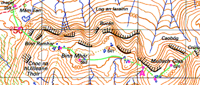 |
| The section of map above includes crags. I would not be sure about the accuracy of the indications of crags marked between Binn Ramhar and the lake. | |
|
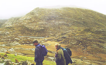
Maumeen. (Pass of the Birds) Each of the four passes through the Maam Turks has its own particular unique charm and also difficulty. As you approach this first one at Maumeen (Mám Éan on MC), with its major lake, the challenge is to arrive without breaking anything! To meet the test, you need to aim slightly left of the lake. (Towards the right in the picture, which is looking backwards.) |
| You can just see what awaits someone veering right on
the descent (left of picture): serious cliffs some 300 m high. Tip. If you do get
lost along the ridge from Mullach Glas, perhaps through missing Binn Mhór in mist, veer
to the left of the ridge. This will add distance but no serious cliffs to your
path. When you do get there, hopefully without mist, take a look around. The charm of this pass is its usually bright airy nature (700 m wide) and L shaped lake set in the bog, such a contrast to the bare quartzite of the tops. Writing about it HC Hart memorably said (I) "An occasional oasis, as at Maumeen, charms the eye with its verdure and some botanical treasures." The steep cliffs to the left of the picture are part of a general geological trend on the Maamturks. The north side of the ridge is steeper, a point worth noting if you need to escape the ridge. JB Whittow in GSI wrote: "All the major corries of the Maumturks show a similar preferred orientation to those of the Twelve Pins, between north and east, for these were the slopes most sheltered from the sun in the northern hemisphere. In addition, if the prevailing winds in the Late Pleistocene were similar to those of today, they they would have served to blow the thick accumulation of snow off the quartzite summits into the lee of the north-eastern facing slopes, thus nourishing the corrie glaciers." There is a picture of one of these superb corries in the next section. |
|
| Continue Tour |
| From "The Illustrated Maamturks Walk" | Part of "Hillwalking in Ireland" at www.simonstewart.ie |