 |
| J.B. Glover: Tributes and Other Articles. |
Muckish to Errigal, Co Donegal, Ireland.
People walk all the time in the mountains of Ireland, often in small, informal groups,
often in larger numbers. In addition there is a tradition of organised long walks which
stretches back over twenty years. These long walks draw numbers from around sixty to over
four hundred and are often held in areas with a great natural challenge. Without doubt one
of the hardest of the organised long walks is the Glover Highlander walk, organised by the
North-West Mountaineering Club. The walk is held to commemorate J.B. Glover (Joey) a major
figure of the club tragically killed in the troubles. Generally it is held in September
each year and follows a route in Donegal. The route first peak is Muckish mountain and its
last Errigal, taking in the intervening summits.
This page is a description of the Glover walk drawing on pictures and details principally
from the 1996 occasion.
The 1997 event was held as scheduled. The weather was extremely windy
at first making Muckish in particular very difficult, however it got better later. 305
people started and most finished. More on 1997 Glover Highlander.
The 1998 event was held on Sat 12th Sept.
For the first time the organisers had limited entry. There were 208 starting, all
pre-entered walkers. The weather was generally appalling with high winds (80 to 90
kph) and heavy showers. On ground over about 400 m the showers were mainly falling
as hail. I got caught in one such shower on the knife edge top of Errigal. All
you could do was concentrate on not being blown off or stung too hard by the hail.
One hundred and thirty finished which was a high proportion given the conditions which
were the worst I have seen. Probably only experienced walkers would have been
organised to pre-enter. There was the usual dinner, dance and general hooley
afterwards ...
Some general information:
Several long walks are shown on this Map, with the
Glover Highlander in the North West.
Clicking below will give you a simulated picture of Ireland centred on the Glover Walk.
You can set various options for example so as to see the updated weather.(be patient, it
is often overloaded) Picture.

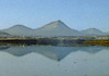
Diagram with names. This picture shows a typical view on the
middle section of the walk. It was taken from the side of Aghlabeg looking forwards along
the direction of the walk towards Aghlamore and the more distant, higher and whiter
Errigal. The nearer lake is Nabrackbaddy, the further Feeane.

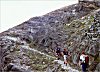
This picture shows the approach to Muckish Mountain. Click on any of the small pictures to
get a larger size (37k).
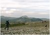
The Miner's Track, near the plateau on top of Muckish. (62k)
In 1996, unlike many years of dreary weather on the organised walk, we emerged on the
summit plateau in relative clarity. As you can see in the next picture, the summit is long
and strewn with brick sized blocks.
The summit of Muckish has a prehistoric cairn on it. This picture is taken from near the
cairn, looking in the direction of the walk. The unusually clear conditions allowed us to
see the major summits of the walk. Crowning the skyline is the last peak: Errigal. (48k)
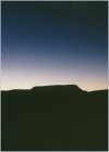
A night view of Muckish. (37k)
En route to Lough Aluirg and Aghlabeg. The first checkpoint in the picture is located in
the hidden ground before the prominent ridge. Aghlabeg is the summit to the right. (39k)

Lough Altan below us, with the last summit, Errigal at the top right. (33k)

Altan Farm, beside Altan Lough. (59k)
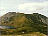
Majestic Errigal, the final peak. Click on any of the small pictures to get a larger size
(59k)
Mail me. (Email address on this page,
bottom right.)
Further Information about the Glover Highlander Walk
Route Card for the Glover Highlander walk in HTML form
Tabular comparison with other organised walks.
Graphical comparison with other organised
walks.(93k)